The highest and largest mountain in mainland South Korea, Jirisan Mountain consists of numerous scenic peaks, including its highest Cheonwangbong Peak (1,915m), Nogodan and Banyabong Peaks, and ridges and valleys extending for 40km from east to west. The mountain borders three provinces, Jeollanam-do, Jeollabuk-do and Gyeongsangnam-do, and its forests account for about 20% of all forestry in Korea. It was designated as Korea’s first National Park in 1967.
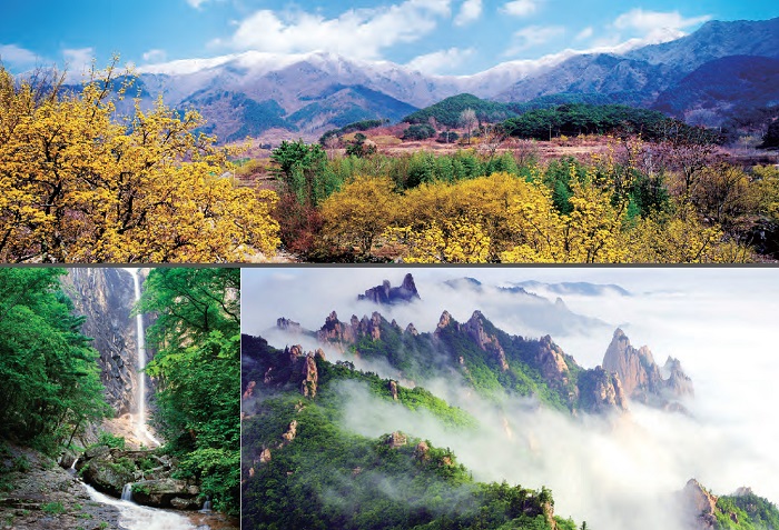
A spring view of Jirisan Mountain (top), Waterfall at Seoraksan Mountain (Sokcho, Gangwon-do) (left bottom), Landscape of Seoraksan Mountain (Sokcho, Gangwon-do)
Jirisan Mountain is located at the southern end of the Baekdu Daegan, a great mountain range that forms the backbone of the Korean Peninsula, running down from Baekdusan Mountain in the northern most part of the peninsula to characterize geographical features of the south. The mountain has been widely admired for its majestic appearance and dense forests providing natural habitats for rare animal and plant species such as the Siberian musk deer, Korean goral, Asian birch, and the Royal Azalea.
Seoraksan Mountain
South Korea’s third highest mountain after Hallasan Mountain and Jirisan Mountain, Seoraksan Mountain is located in the middle of the Baekdu Daegan, a great mountain range forming the backbone of the Korean Peninsula, with its tallest peak Daecheongbong (1,708m) overlooking Korea’s eastern coast. The mountain is characterized by rocky peaks and cliffs displaying grotesque shapes and deep valleys containing pools of crystal clear water which have led to it being compared with Geumgangsan Mountain, or the “Diamond Mountain” in the North, which has long been admired as Korea’s number one scenic mountain.
The mountain covers a vast area on the mid-eastern part of the Korean Peninsula which is divided into three areas, namely, Oeseorak (Outer Snowy Mountain) in the east of Daecheongbong Peak, Naeseorak (Inner Snowy Mountain) in the west, and Namseorak (Southern Snowy Mountain), which contains the famous mineral spring called Osaek Mineral Springs in the south. The mountain also contains the source of the Namdaecheon Stream, which flows through the Yangyang area into the East Sea, and the Bukhangang and Soyanggang Rivers, which flow westwards to form the Hangang River which cuts across Seoul.
Seoraksan Mountain provides a safe haven for many native or endangered species such as the Manchurian trout, Korean minnow, diamond bluebell (geumgang chorong), and edelweiss. The mountain was designated as a National Park in 1970 and registered on the World Network of Biosphere Reserves by UNESCO in 1982. It is also home to many historic, cultural and natural heritage including Buddhist temples such as Baekdamsa, Sinheungsa and Bongjeongam, which is one of the five temples enshrining the relics of Shakyamuni, the historical Buddha, Heundeulbawi Rock, and Ulsanbawi Rock , an 873-meter-tall rocky peak of majestic appearance.
Seoraksan Mountain is famous for the breathtakingly beautiful landscapes created by its mountain peaks, deep valleys, stunning rock formations, and historic Buddhist temples which draw millions of hikers from all across the country every year. Meanwhile, in Seorak-dong, a tourist town located on the foot of the mountain containing an entrance to it, there is a fine network of accommodations and recreational facilities that form a convenient environment for tourists and hikers. Tourism in Seoraksan Mountain is typically connected with the presence of Goseong Unification Observatory, which is located close to the DMZ on the east coast.
Namsan Mountain and Bukhansan Mountain
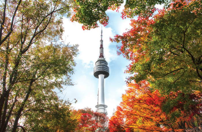
Namsan Seoul Tower, a landmark and top tourist spot in the capital
Namsan Mountain, a 262-meter-tall mountain standing in the heart of Seoul, is home to a number of attractive walking trails appreciated by the citizens of Seoul for hundreds of years. The mountain is dense with trees that provide an abundance of fresh air and flowers all year round.
By walking along trails, it usually takes about 1 hour to reach the summit via any of the paths. Atop the mountain sits Namsan Seoul Tower (or the N Seoul Tower) and an octagonal pavilion. There is also a sign that denotes the “Geographical Center of Seoul.” Visitors can also take environmentallyfriendly buses or cable cars to get to the top. As well as a historic beacon fire station used for long-distance communications during the Joseon Period (1392-1910). At the foot of the mountain there are several cultural institutions such as the National Theater of Korea, Seoul Municipal Library, and Namsangol Hanok Village.
The Bukhansan National Park on the northern part of Seoul also provides popular venues for various outdoor activities, hiking and rock climbing in particular.
Rivers of Korea
Two large watercourses originating from the mid-eastern mountainous region of the Korean Peninsula merge together to become the Hangang, or the Hangang River, which passes through Seoul before flowing into the West Sea . The rivers have provided water for all the fields and factories in and outside the capital area and drinking water for many cities within it including Seoul. The rivers are installed with multiple dams including those for flood control and generating power.
The longest river on the Korean Peninsula is the Nakdonggang River which cuts a 520km-long course across Gyeongsangbuk-do Province and Gyeongsangnam-do Province before flowing into the South Sea. Its estuary contains a large delta called Eulsukdo where reeds grow densely, forming Asia’s largest bird sanctuary. Other major rivers in Korea include the Geumgang and Yeongsangang Rivers which provide water for Korea’s largest granary in the southwest, and the Imjingang, Mangyeonggang and Seomjingang Rivers, which also constitute important sources of water for the rest of Korea.
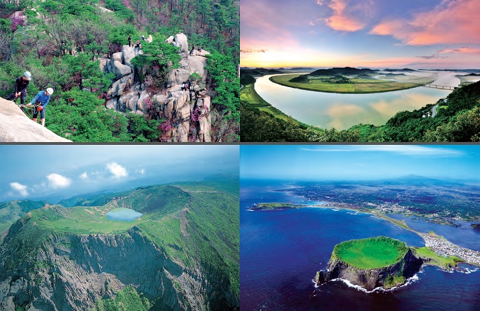
(Clockwise from left top) Rock climbing at Bukhansan Mountain, A view of the setting sun over Yeongsangang River, the main source of water for the southwest of Korea, Seongsan Ilchulbong Tuff Cone on Jejudo Island; One of many parasitic cones scattered around Jeju, Baengnokdam Crater Lake of Hallasan Mountain; A cauldron-shaped volcanic crater (108m in depth and 1,720m in circumference) atop Hallasan Mountain
Jejudo Island
Jejudo(do is Korean for island), Korea’s largest island (approx. 73km from east to west, 31km from south to north), lies in the Korean Strait, southwest of the Korean mainland. The oval-shaped island maintains a rich cultural heritage that is distinctly different from that of the mainland. It is also the only province of Korea where mandarin oranges are grown in natural conditions, providing a great source of income for many households since the 1960s. It was an extremely popular honeymoon destination among mainland Koreans during the 1970s and 1980s, and has since grown into one of Korea’s top tourist attractions, drawing hundreds of thousands of tourists from neighboring countries including Japan and China. In 2006, the Korean government designated the island as Jeju Special Self-Governing Province in an effort to turn it into a Free Trade Zone. It is now a very popular venue for important international gatherings including summit meetings.
Jejudo was formed by a series of volcanic eruptions and is rich with the distinctive features of volcanic topography including 368 oreum (parasitic cones) and about 160 lava tubes. This unique natural heritage led to the island’s inclusion on the UNESCO’s World Network of Biosphere Reserves in 2002, World Heritage Sites in 2007, and Global Geoparks Network in 2010. The worldwide recognition of Jejudo as a global natural heritage is expected to further promote the value of the island as a tourist destination and as one of Korea’s key environmental assets.
The Culture of Jeju Haenyeo (Women Divers) was inscribed on the Representative List of the Intangible Cultural Heritage of Humanity by UNESCO in 2016. Jejudo Island is indeed globally recognized not only as a popular tourist destination but also as an “island of environmental and cultural treasures.”
Hallasan Mountain, a dormant volcano, soars upwards from the center of Jejudo to a height of 1,950 meters, making it the highest mountain in South Korea. The mountain is home to over 1,800 species of alpine plants that select their habitats according to altitude and exhibits great diversity of vegetation. The mountain largely consists of basalt, and slopes steeply in the south and more gently in the north. There is a crater lake, Baengnokdam, at the summit.
Seongsan Ilchulbong Tuff Cone, situated at the eastern tip of Jejudo, is probably the most popular tourist attraction on the island. This 182-metertall volcanic peak is said to resemble a huge amphitheater with a deep, bowllike center filled with reeds and rimmed with rocky cliffs. Many visitors also compare this popular sunrise celebration venue, which is now designated as a Natural Monument, with a heavily fortified, impregnable castle or a tall, full-circle tiara.
Other key attractions reflecting the natural wonders of Jeju include Yongcheondonggul Cave, located in Woljeong-ri of Gujwa-eup, which exhibits a unique combination of the characteristic features of both lime caves and lava tubes, the lime caves in Hyeopjae and Pyoseon, and the Gotjawal forests which formed on the rocky areas thrown up during a volcanic eruption. These forests provide natural habitats for rare plants, some of which are suited to cold climates while others are more typical of tropical or subtropical areas. These untouched, densely wooded forests are often referred to as the “lungs of Jeju.”
The Jungmun Tourist Complex located on the southern coast in Seogwipo boasts many fascinating places and facilities for a variety of outdoor activities, including swimming and sunbathing, golfing, horse riding and hunting, world-class hotels, and enchanting natural attractions such as the three-tier waterfalls of Cheonjeyeon and coastal columnar jointing. A new attraction was added to the already long list recently when one of Asia’s largest aquariums, Aqua Planet, was opened in July 2012 at Seopjikoji Beach in Seongsan-eup.
One of the island’s main attractions, the recently created Jeju Olle Trail, comprises a set of nature trails along the coast that lead hikers to fascinating views of Jeju, old villages and fields enclosed or separated by basalt stone walls, coastal seas where elderly women divers (haenyeo, “sea women”) harvest seafood beneath the sea, and waves of wind rolling through fields of long grass (Jeju has been called Samdado, literally, the “island of three abundances”, namely, stones, women, and wind).
Jejudo is famous for its many special farming and marine products of which the “prickly palm cactus” (Opuntia ficusindica), also known as baengnyeoncho (hundred-year plant), has recently amazed many scientists of the world for its extraordinary beneficial effects on human health. Dol hareubang, the iconic grandfather statues carved from porous basalt (volcanic rocks), are also popular souvenirs. For some Korean tourists, Jeju is significant in that it has jurisdiction over the southernmost part of the Korean territory, a tiny island called Marado located about 10km off its southwestern coast, and Ieodo, a submerged rock 4.6 meters below sea level located 149km southwest of Marado, the location of the Ieodo Ocean Research Station.
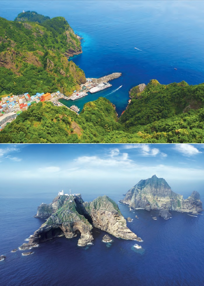
Dodong Port in Ulleungdo (top): A volcanic island lying in the East Sea and Dokdo (Ulleung-gun, Gyeongsangbuk-do): Dokdo consists of two rocky islets, Dongdo and Seodo, situated about 150 meters apart, and 89 rocky outcrops around them.
Ulleungdo and Dokdo
Located about 130km east of the Korean Peninsula, Ulleungdo is a volcanic island of about 72km2 that is rimmed with steep rocky cliffs and has a basin (called Nari Basin) on the top. It is historically connected with a group of rocky islets called Dokdo situated 87.4km to its southeast, thus forming the easternmost part of the Korean territory. Now guarded by the Dokdo Coast Guard, Dokdo consists of two large rocky islets and eighty-nine small rocks, and is home to about seventy plant species, although most of the islets are barren. It was designated as the Dokdo Seabird Breeding Area and Natural Monument No. 336 in 1982 and then as the Dokdo Protection Area in 1999.
Hallyeosudo (Hallyeohaesang National Marine Park)
The area of coastal seas ranging from Yeosu in Jeollanam-do Province to Hansando in Gyeongsangnam-do Province has long been praised for its breathtakingly beautiful seascapes characterized by sparkling blue seas, islands of all sizes, fantastically-shaped rocky cliffs, and dramatic coastlines. The area is also famous as the habitat of diverse marine species, and became Korea’s first national marine park in 1968.
Yeosu, one of Korea’s leading industrial cities and host of the World Expo in 2012, contains some of the most popular tourist attractions in the national marine park such as Odongdo, a tiny islet covered with camellia trees, beautiful beaches, and historic sites related with the victories of the Joseon navy, under the leadership of Admiral Yi Sun-sin, against the Japanese forces that invaded Korea in 1592. A new attraction was added in February 2013 with the opening of Yi Sun-sin Bridge connecting two of the largest industrial cities in the area, Yeosu and Gwangyang.
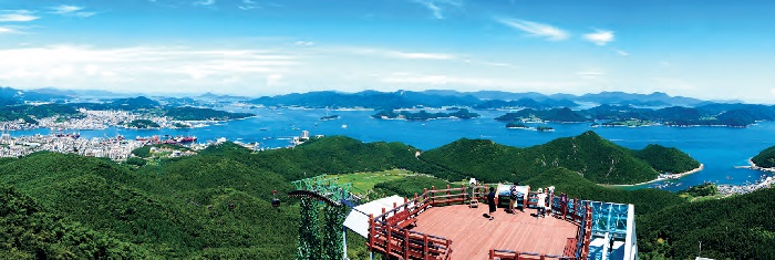
Hallyeosudo: Korea’s first national marine park - famous for the spectacular seascapes created by many differently-sized islands floating on blue seas.
Namiseom Island
Namiseom Island - located 3.8km south of Gapyeong-gun, Gyeonggi-do Province, in the middle of a large artificial lake created by Cheongpyeong Dam, built in 1943 - has become a very popular tourist attraction among Hallyu (Korean Wave) fans across Asia thanks to the huge success of the TV series Winter Sonata, parts of which were filmed here. The island is dense with trees including Korean nut pine, dawn redwood, white birch and gingko, creating a number of romantic nature trails. In addition to walking, the island offers visitors places and facilities for various indoor and outdoor activities including cycling courses, art galleries, museums, craft workshops, bungalows and campsites.
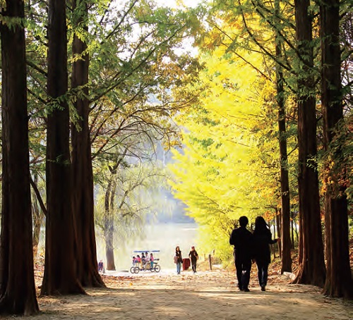
Metasequoia Forest Walkway on Namiseom Island
Korean Demilitarized Zone
The cessation of the Korean War in 1953, following the signing of the Korean Armistice Agreement, led to the creation of the Military Demarcation Line (MDL) and the Korean Demilitarized Zone (DMZ), which is 250km long and approximately 4km wide, i.e. 2km on the South’s side and another 2km on the North’s. On the western part of the DMZ there is a farming village called Daeseongdong, better known as “Freedom Village” among South Koreans.
Civilian access to the DMZ is normally restricted, but allowed for those who receive a permit issued by the military. The same applies to foreign tourists. The prohibition of public access to the DMZ for the last 60 years has helped maintain the environment in pristine condition, a quality for which in recent times it has attracted the interest of scientists and conservationists the world over.
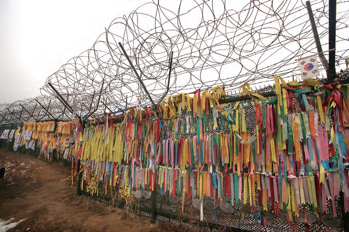
Prayer ribbons tied to a barbed wire fence located between the DMZ and Freedom Bridge
